GPS Usage under IFR
Objective
The student will have knowledge of GPS operation, including its principles, capabilities, limitations, and the necessary procedures for utilizing the GPS system for navigation and instrument procedures under IFR
Timing
45 minutes
Format
- Garmin GTN Trainer
Overview
- GPS Principles of Operation
- Receiver Autonomous Integrity Monitoring (RAIM)
- GPS Errors & Irregularities
- Wide Area Augmentation System (WAAS)
- GPS Modes of Operation
- GPS Use Under IFR
- GPS CDI Scaling (En Route, Terminal, & Approach)
- GPS Waypoints
- GPS Direct-To Operations
- GPS Flight Plan Operations
- GPS Nearest Functions
- Substitution of GPS for Other Navigation Radios Under IFR
- Orientation, Position, and Waypoint Passage / Sequencing
- GPS Course Intercepting and Tracking Procedures / Wind Correction Techniques
- Computer / App Based GPS Procedures Simulator
- Installed GPS Specific Procedures
Elements
GPS Principles of Operation
- GPS is a satellite-based radio navigation system
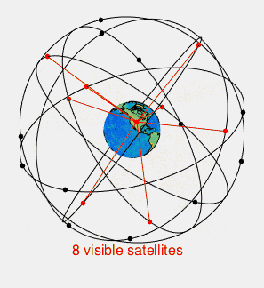
- Space Element consists of over 30 Navstar satellites
- The satellites broadcast a pseudo-random code timing signal and data message
- Satellites transmit position, velocity, and precise timing
- At least five satellites are designed to be in view to a user worldwide
- Control Element is a network of ground-based monitoring and control stations
- Monitoring stations ensure the accuracy of satellite positions and clocks
- User Element consists of antennas and receiver/processors onboard the aircraft
- The receiver requires a minimum of four satellites for a three-dimensional position solution (latitude, longitude, and altitude)
- The receiver computes distance based on signal travel time (pseudo-range)
- Position is determined by triangulation using the pseudo-range and position information supplied by the satellite
- Other countries have their own satellite navigation systems, such as Russia's GLONASS, the European Union's Galileo, and China's BeiDou.
Receiver Autonomous Integrity Monitoring (RAIM)
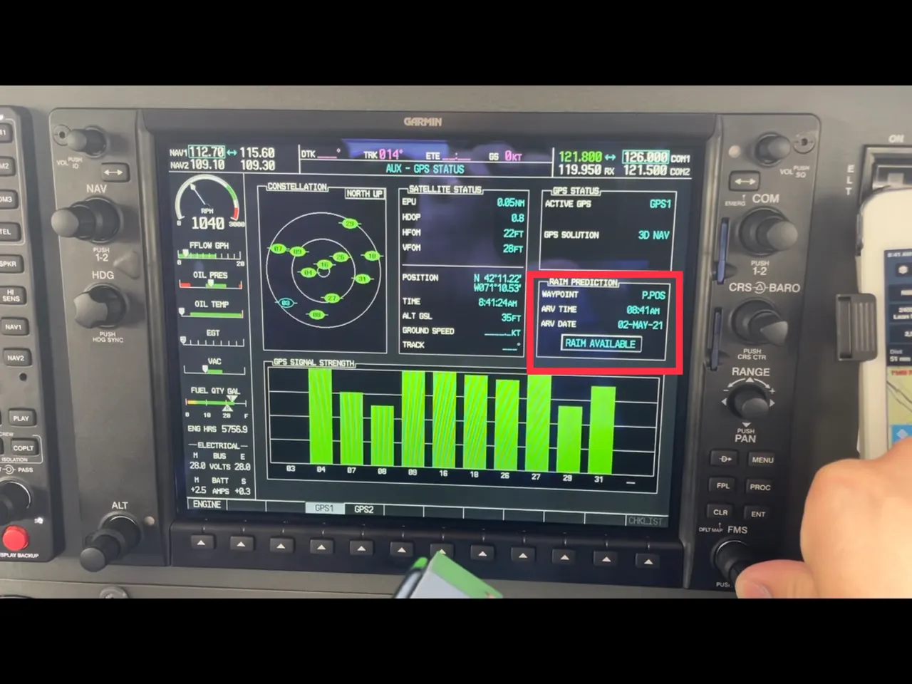
- RAIM is the capability of a GPS receiver to monitor its own integrity
- It uses extra satellites to compute multiple positions
- RAIM requires a minimum of five satellites in view, or four satellites and barometric altimeter input (baro-aiding), to detect an integrity anomaly
- Some receivers are capable of fault detection and exclusion (FDE) that require 6 satellites in view (or 5 satellites with baro-aiding)
- FDE allows the receiver to isolate a corrupt signal and remove it from the position solution, while still providing an integrity-assured position
- The two general types of RAIM messages are:
- Insufficient satellites to provide integrity monitoring
- RAIM integrity monitor detects a potential error exceeding the limit for the phase of flight
GPS Errors & Irregularities
- GPS positioning data can be affected by various geometric factors and equipment characteristics, typically causing errors of less than 100 feet
- Small position errors or momentary loss of signal can be caused by:
- Satellite atomic clock inaccuracies
- Receiver/processors
- Signals reflected from hard objects (multi-path)
- Ionospheric and tropospheric delays
- Satellite data transmission errors
- Loss of signals may occur in valleys surrounded by high terrain
- Loss of satellite reception may occur due to aircraft dynamics (changes in pitch or bank angle)
- Jamming (emissions that interfere with signal reception) and spoofing (emissions that mimic GNSS signals) are intentional unauthorized interference that can disrupt air navigation
- The U.S. government regularly conducts GPS testing that interferes with GNSS signals, which are geographically limited, coordinated, scheduled, and advertised via NOTAMs
Wide Area Augmentation System (WAAS)
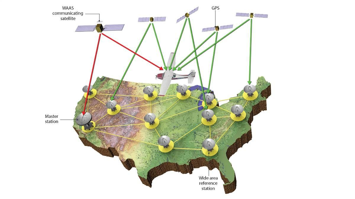
- WAAS is designed to improve the accuracy, integrity, and availability of GPS signals
- It is the U.S. version of a satellite-based augmentation system (SBAS)
- Allows GPS to be used for takeoff through Category I precision approaches
- A network of Wide-Area Reference Stations (WRS) on the ground monitors GPS signals for errors
- WRS relays data to a Wide-Area Master Station (WMS)
- The WMS calculates correction information and uplinks a message to a Geostationary Earth Orbit (GEO) satellite
- The GEO satellite broadcasts the WAAS-corrected signal on the same frequency as GPS (L1, 1575.42 MHz) to WAAS receivers
- The GEO satellite also provides an additional pseudo-range measurement, improving GPS availability
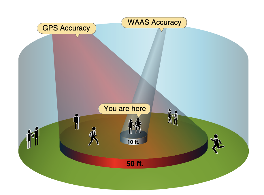
- The accuracy is good enough to provide GPS/WAAS glide paths (vertical guidance)
- LPV (Localizer Performance with Vertical Guidance) uses WAAS accuracy to provide an approach similar to a Category I ILS
- LPV minimums are published as a Decision Altitude (DA)
- LP (Localizer Performance) is a WAAS-based line of minima that provides angular lateral guidance and is published as a Minimum Descent Altitude (MDA)
- LPV (Localizer Performance with Vertical Guidance) uses WAAS accuracy to provide an approach similar to a Category I ILS
GPS Modes of Operation
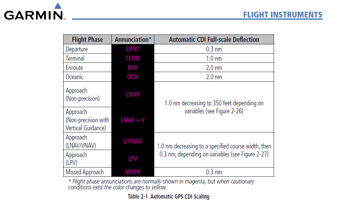
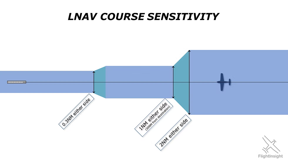
GPS CDI sensitivity changes based on the phase of flight
- En Route: Typically ±5 NM CDI sensitivity, but may be lower (see G1000 image above)
- Terminal: ±1 NM CDI sensitivity
- Terminal mode automatically activates when the aircraft is within 30 NM of the airport
- Approach: ±0.3 NM CDI sensitivity
- Approach mode becomes active when the aircraft is within 2 NM of the Final Approach Waypoint (FAWP)
- CDI sensitivity smoothly changes (ramps down) from ±1 NM to ±0.3 NM at the FAWP
- Missed Approach: CDI sensitivity immediately changes to terminal (±1 NM) sensitivity
GPS Use Under IFR
- GPS must be TSO-certified (C129, C196, C145, or C146) and the installation approved per AC 20-138
- GPS operations must be conducted in accordance with the AFM or flight manual supplement
- Non-WAAS GPS (TSO-C129/C196) aircraft must be equipped with an alternate approved and operational means of navigation
- GPS RAIM availability must be checked before IFR operations
- If a continuous RAIM loss is predicted for more than 5 minutes, the flight must be delayed, canceled, or re-routed
- See AIM 5-1-16 for more details
- WAAS (TSO-C145/C146) users do not need to perform RAIM prediction if WAAS coverage is confirmed along the entire route
- The onboard navigation database must be current and appropriate for the operation
- Procedures must be retrievable by name from the database; manual entry of waypoints is not permitted for approach procedures
- Pilot should review appropriate NOTAMs before GPS IFR operation
GPS Waypoints
- Waypoint (WP) is a predetermined geographical position defined by latitude/longitude coordinates
- WPs are used to indicate a change in direction, speed, or altitude
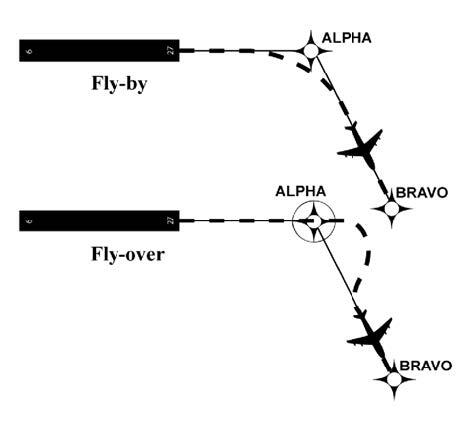
- Fly-by (FB) Waypoints are used when a turn should begin prior to reaching the waypoint (turn anticipation)
- Chart symbol: Four-pointed star
- Fly-over (FO) Waypoints require the aircraft to fly over the point prior to starting a turn
- Chart symbol: Four-pointed star enclosed in a circle
- The MAWP is always a fly-over waypoint
GPS Direct-To Operations
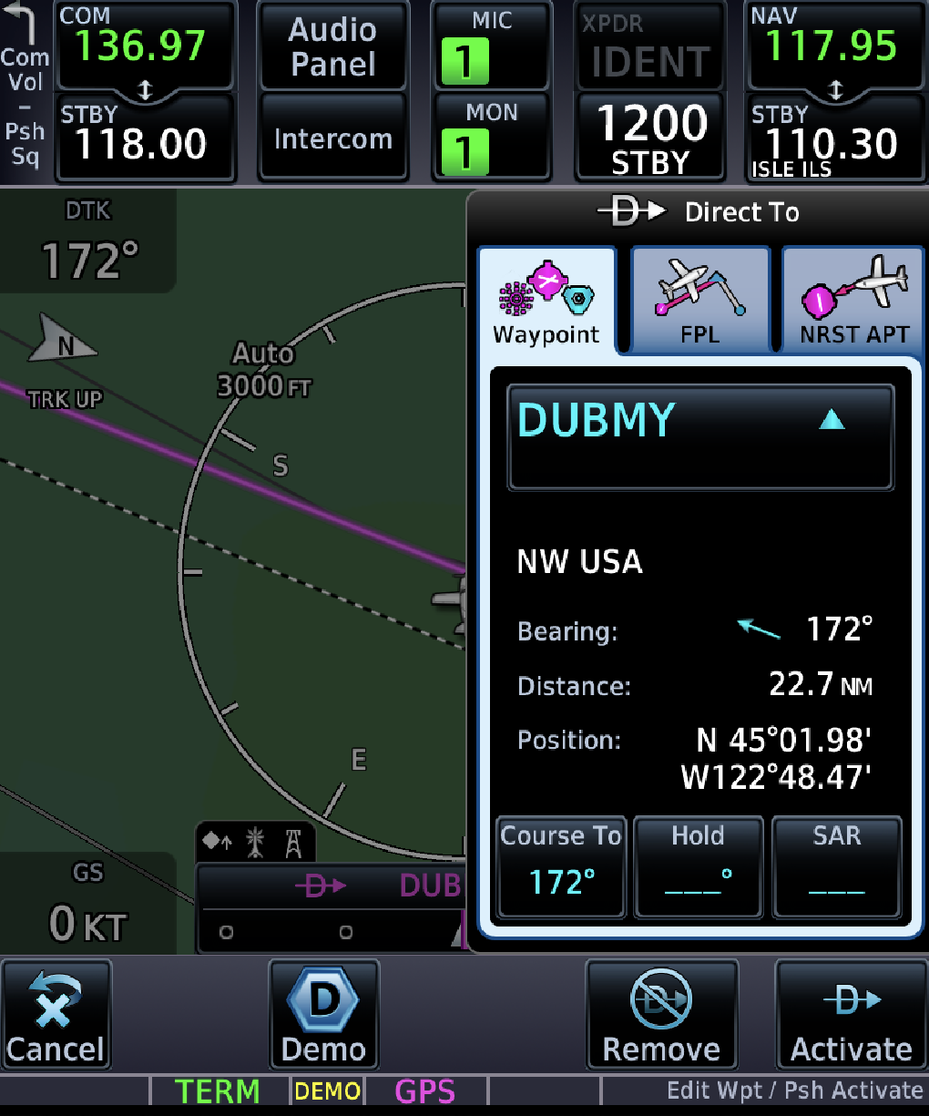
- A Direct to Fix (DF) leg defines an unspecified track from an undefined position to a specific database fix
- Generally there are two types of Direct-To:
- On-route direct-to, where you navigate directly to a fix in your flight plan (the flight plan will then sequence from there)
- Off-route direct-to, where you navigate to an arbitrary fix (flight plan sequencing will suspend when you arrive at the fix)
- ATC may clear an aircraft direct to a fix when issuing approach clearance
GPS Flight Plan Operations
- ICAO Flight Plans require two codes:
- Equipment codes (nav capability)
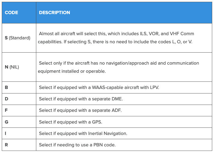
- See more about ICAO equipment codes here
- Surveillance codes (transponder/ADS-B)
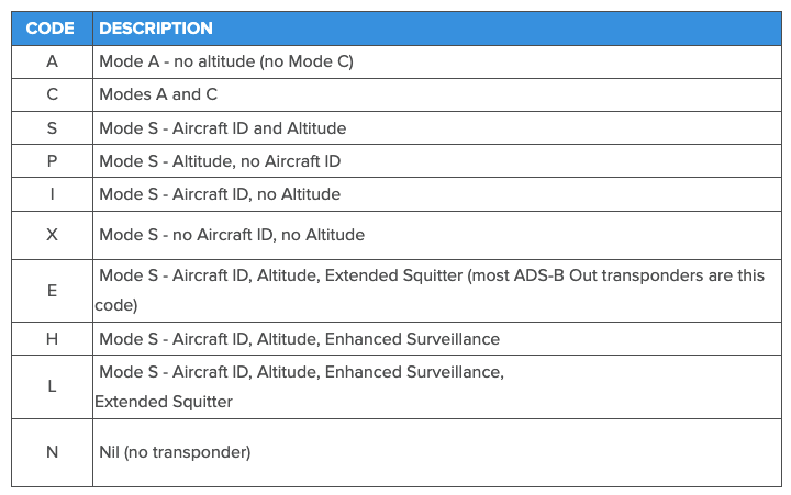
- See more about ICAO surveillance codes here
- Equipment codes (nav capability)
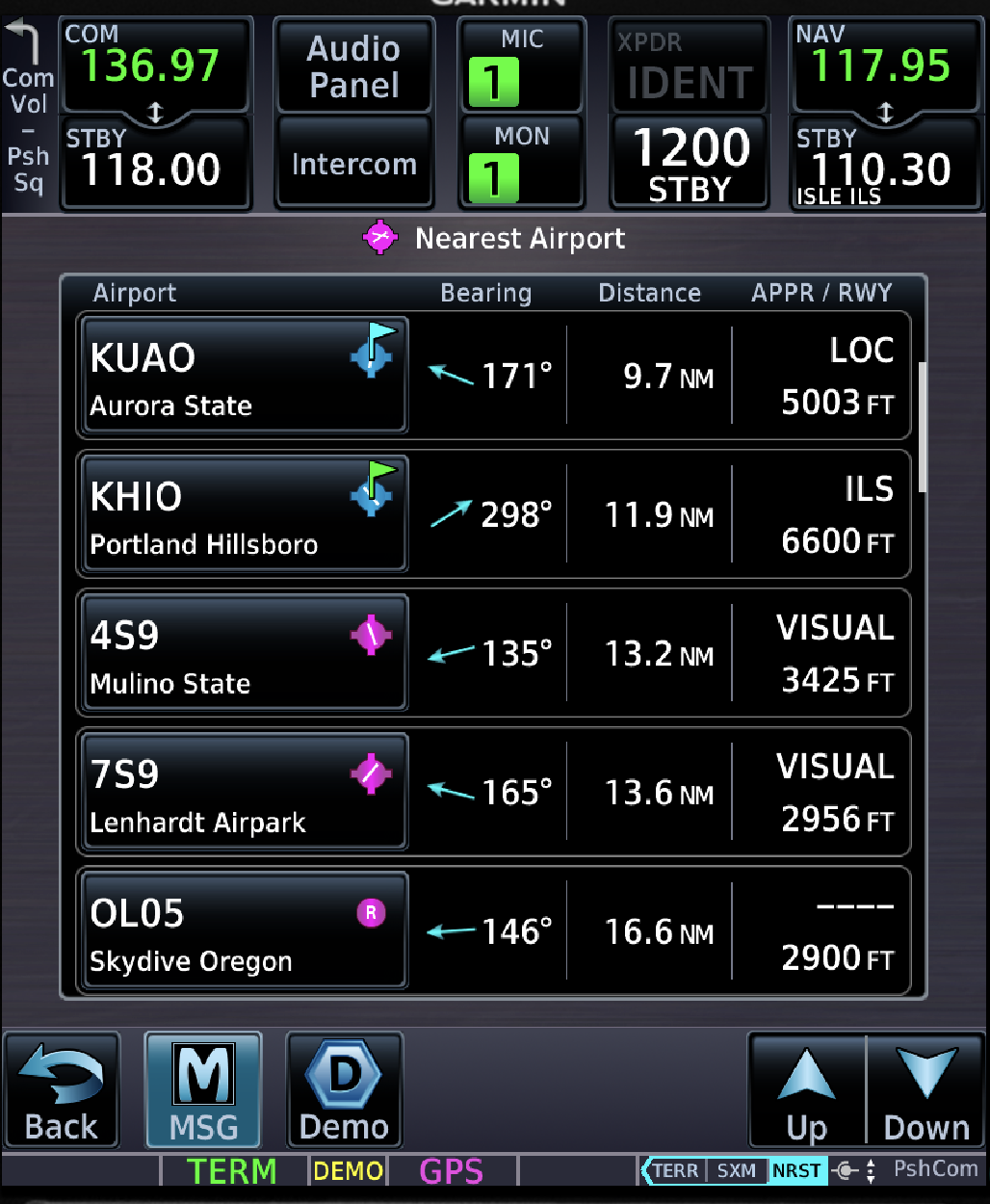
GPS Nearest Functions
- GPS displays can provide information on nearest airports
- The display can show information including runway length, surface, available approaches, and communication frequencies
- The nearest airport function allows the pilot to activate a Direct-To course to the selected airport
Substitution of GPS for Other Navigation Radios Under IFR
- IFR-certified GPS systems may be used as a substitute for traditional NAVAID navigation
- This application requires the system to have en-route RAIM or WAAS
- GPS can be substituted to:
- Fly a DME arc
- Navigate TO or FROM an NDB/compass locator
- Hold over an NDB/compass locator
- Determine position over a NAVAID
- Pilots may not substitute for the NAVAID (for example, a VOR or NDB) providing lateral guidance for the final approach segment
- Use of a suitable RNAV system as a means to navigate on the final approach segment of an instrument approach procedure based on a VOR, TACAN or NDB signal, is allowable, so long as the nav signal is monitored for final segment course alignment
- Exception: GPS may be used on overlay approaches with "or GPS" in the title
Orientation, Position, Waypoint Sequencing
- GPS provides linear course guidance between waypoints
- Position information
- Along Track Distance (ATD) is displayed to the next active waypoint, not necessarily a ground-based NAVAID
- The receiver sequences to the next waypoint when the current one is passed
- This may be prevented by placing the receiver in non-sequencing mode (often referred to as
OBSorHOLD) SUSmode indicates that automatic sequencing is suspended- The Missed Approach Waypoint (MAWP) requires pilot action to sequence the receiver
- This may be prevented by placing the receiver in non-sequencing mode (often referred to as
GPS Course Intercepting, Tracking Procedures, Wind Correction Techniques
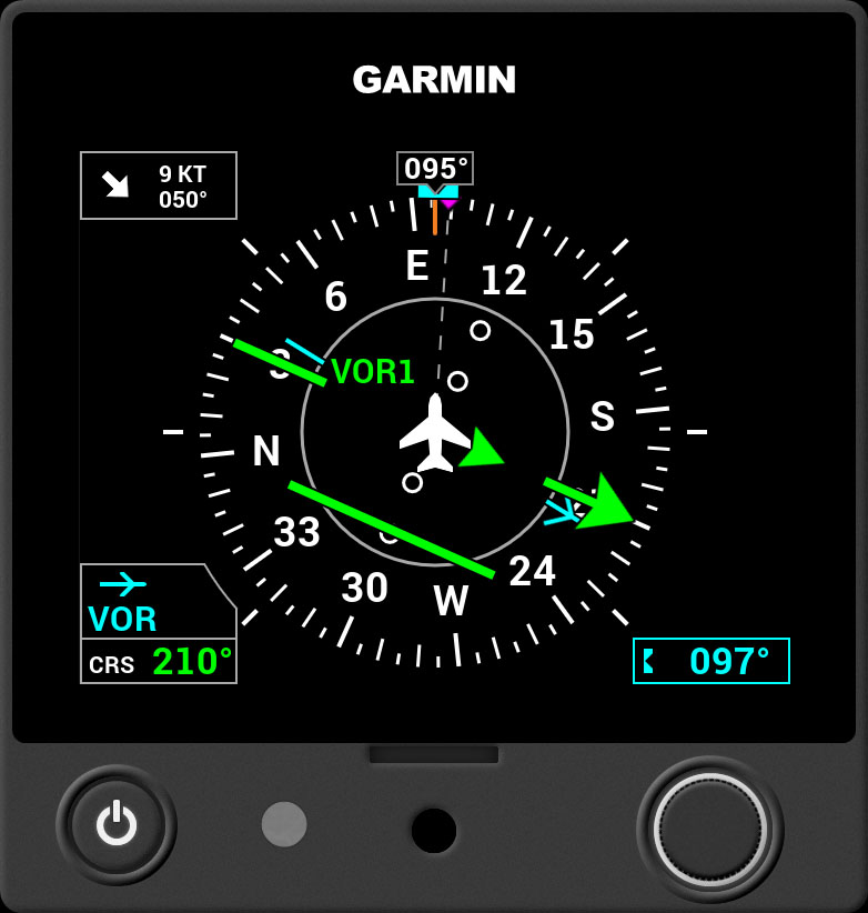
- Match your current track (
TRK) with the desired track (DTK) - The difference between the aircraft’s heading and ground track visualizes wind drift
- This information, often displayed on the MFD, simplifies crosswind corrections
- To maintain the desired track (course), pilots must crab the aircraft into the wind
- Garmin HSI's show ground track as a magenta diamond
Computer / App Based GPS Procedures Simulator
- Computer-based tutorials or simulations are often provided by manufacturers to allow pilots to become familiar with the equipment’s operation
- Practice should include:
- Programming approach procedures (especially procedure turns and arcs)
- Programming and flying holding patterns
- Programming and flying missed approaches
- Indicating actions required for RAIM failure
See the Avidyne IFD Trainer App and the Garmin GTN Trainer App
Installed GPS Specific Procedures
- Discuss specifics of Garmin GTN or Avidyne IFD
- Garmin
- "Activating" an approach just means going direct-to the initial approach fix (IAF)
- On old units, when flying a vectors-to-final approach, it can be helpful to still load an approach with a transition (rather than the
Vectors to Final Mode)- This loads all of the previous waypoints into the approach, in case you need to reference them
- Avidyne
- Garmin
References
- AIM 1-2-3
- Instrument Flying Handbook pg. 9-24: GPS System and Use
- Instrument Flying Handbook pg. 10-1: IFR Flight Plans