Completing a Navlog
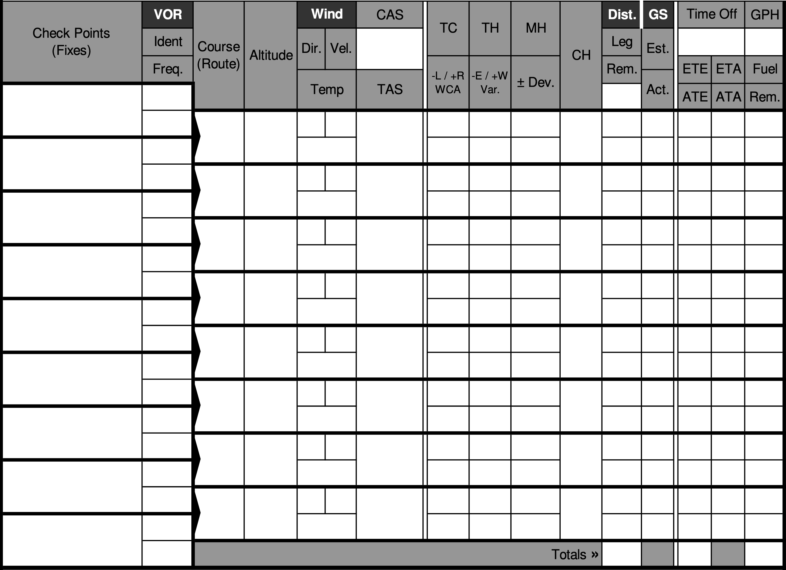
As part of filling out a navlog, pilots will need to estimate the magnetic course to fly, and ground speed based on the aircraft's performance and winds aloft.
Before you can fill out the navlog, you will need to have:
- Your route of flight
- Your cruising altitude
- The winds and temperatures aloft (probably from a weather briefing)
- The cruise performance table of the aircraft's manual
- The compass card for your airplane

Step 1: Determine True Course and Distance Between Legs
First, determine the true course between. This is course relative to true north, and can be determined using a plotting tool on a section, or with a mapping tool.
Next, determine the distance in NM. Note this on your navlog in the leg distance columns.
Step 2: Determine the Winds and Temperatures Aloft for the Leg
Using a winds aloft forecast from your weather briefing, determine the estimated wind direction, velocity, and temperature aloft. Record these in the Wind Dir., Vel., and Temp columns.
Step 3: Determine True Airspeed for Cruise
Using the table in the aircraft's manual, your cruising altitude, and temperature aloft, estimate the true airspeed at which you will be travelling on this leg. Record this number in the TAS column.
Also, look for the fuel burn rate on the chart, and note this in the GPH in the fuel column.
Step 4: Compute the True Heading
Using your E6B, compute the wind correction angle. This uses the wind direction, wind speed, true course, and true airspeed to compute an offset of your course which accounts for wind drift. This is called the Wind Correction Angle (WCA), note it in the WCA column.
This step will also compute a groundspeed. Note this in the estimated ground speed (GS) column.
Add the WCA to your true course to get the true heading (TC), note this in the TC column.
Step 5: Compute Magnetic Heading
Next, look at the section for straight magenta dashed lines. These lines are called isogonic lines, or lines of equal magnetic variation. Find the one closest to your route segment.
- If the line is labelled something like 15° E then you will subtract the offset
- Likewise if it says something like 5° W, add the offset
This is converting your true heading to a magnetic heading. Not this offset in the Var. column, and then add or subtraact it to the true heading to get your magnetic heading (MH). Note this in the MH column.
Step 6: Determine the Magnetic Deviation
Using the compass card for your airplane, determine the magnetic deviation. This is accounting for errors from magnetic fields present in your airplane. Note the correction in the TH Dev. column, and then add it to your magnetic heading to determine your course heading (CH).
Step 7: Compute Time Enroute and Fuel Burn
Now that we know our groundspeed and distance, we can compute our estimated time enroute (ETE) for this leg. Simply divide the distance (in NM) by the ground speed (in knots) to determine the time in hours. Multiple this by 60 to get minutes, if you prefer.
Next multiple your fuel burn rate (in gallons per hour) by your time enroute for that leg (in hours) to compute the estimated gallons of fuel you will burn.